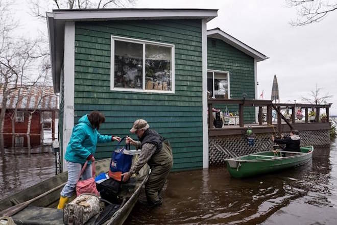
The Emergency Measures Organization in New Brunswick is urging people to leave certain neighbourhoods in and around Saint John due to rising floodwaters that could surpass record-setting water levels in 1973.
The organization said access to several areas, including Randolph, Westfield Road, Ragged Point Road and Beach Road, is limited and will likely be completely cut off by worsening flooding in a region that stretches from Fredericton to the Saint John area.
Spokesman Geoffrey Downey said Wednesday that while attention has been focused on flooding in Fredericton over the last several days, concern is mounting in several areas south of the capital that are being inundated by the heavy rains and melting snow that have swollen the Saint John River.
“A few of them are looking at flood levels rivalling 1973, which is the worst on record,” he said. “For every community south of Fredericton, we’re asking that they be on high alert, that they consider their property’s flood history and give serious consideration to self evacuation.”
Related: Officials warn B.C. flooding may be worse due to 2017 wildfires
Related: RCMP offer to airlift people trapped by flooding in Cariboo
EMO says the voluntary evacuation notice could affect about 1,900 people in Saint John, who should make their own arrangements or go to the Carleton Community Centre or contact the Canadian Red Cross.
Water levels along the Saint John River are expected to continue to rise through the week, isolating homes and leading to further road closures. NB Power has also turned off electricity to about 104 customers for safety reasons.
Downey said more than 30 homes had been evacuated so far, affecting about 100 people. He expected that number would rise around Saint John and urged people to leave their homes if floodwaters are rising around them, adding that they should take their pets, medications, clothing and identification.
“Doing it in the daylight when you still have dry roads is far easier and safer than having to call someone in the middle of the night because you’ve realized your house is under water and your car is under water and the only way to get out is in a boat,” he said.
Water levels were at about five metres in Saint John and could reach 6.6 metres by Sunday, exceeding the 2008 flood level by over a meter, he said.
EMO says people in southern regions of the Saint John River basin should expect similar or worse conditions than previous floods in communities stretching from Jemseg, Gagetown, Hampstead, Oak Point south to Quispamsis.
Downey said the record for Maugerville was 7.11 metres of water and the forecast is calling for 7.1 metres, while in Jemseg the forecast was for 6.7 metres Thursday which would surpass the record of 6.36 metres in 1973.
There is rain in the forecast and snow in the north, which is expected to make the situation more dire in the coming days. Much of the sitting water also won’t recede quickly, he said, adding that the Fredericton area has been at about eight metres since late last week.
“For a lot of people, the worst is yet to come and it’s not going to be over any time soon,” Downey said.
“Once they reach those levels, they can pretty much count on it remaining that way for days. It doesn’t seem to be a flood that’s going to rise and drop quickly.”
In the Fredericton region, water levels are forecast to remain at their current levels.
Other waterways were also at risk of flooding, including the Nashwaak, Salmon, Middle and Tetagouche rivers, EMO said.
Related: East coast begins massive cleanup after downpours knock out roads, power
The Canadian Press


