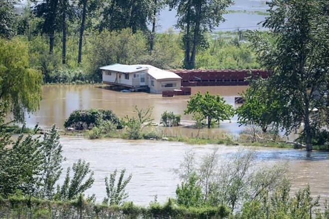
There is a feeling of ”calm apprehension” in the southern British Columbia city of Grand Forks as officials warn of a coming second wave of flood waters, says Brett Swope.
The pastor at the Grand Forks Baptist Church said he noticed the flood waters returned on Tuesday when he drove down a local road covered in 15 centimetres of water. It had been dry on Monday, he said in an interview as he travelled around assessing the flood situation.
The residents of Grand Forks were unsure what water levels to expect in the coming days, Swope said.
“Some forecasts are calling for it to be higher, others are calling for it to be just lower than we had recently, but everybody’s just sort of bracing for the impact and trying to do everything they can to be prepared,” he said.
At least 1,500 homes in the Kootenay Boundary regional district, which includes Grand Forks, remained evacuated Tuesday following flooding over the last several days. Provincial officials say evacuation orders covered another 500 homes around the province, while more than 2,600 homes were on evacuation alert.
Related: Public safety minister visits Boundary flooding
Related: Need to know: How to help, where to donate, and what to do now
Swope said he’s been amazed at the community’s tireless labour.
“When I think of the sense of how our community is feeling, I think that they’re, you know, kind of approaching everything with a calm apprehension.”
He said “hundreds upon hundreds” of volunteers have prepared tens of thousands of sandbags in advance of potential flooding this week and residents are working from sun up to sun down.
Jessica Mace of the Kettle River Watershed Authority said temperatures higher than 30 C and exhausting work is wearing on the thousand plus volunteers in Grand Forks.
“People have been working really long hours,” said Mace, “they’re so thirsty and tired and worn out.”
Heavy rains and spring runoff combined to push floodwaters to levels not seen in 70 years in and around Grand Forks last week.
Gordy Shaw moved to Grand Forks with his wife eight years ago from Richmond because he said he was worried about dykes bursting in the Metro Vancouver city.
“I worked all the sawmills along the Fraser River, and I never anticipated this little Kettle River (in Grand Forks) would ever flow like it did today.”
Shaw said he had about 30 centimetres of water seep into his garage and learned over coffee with his neighbours on Tuesday that he was lucky compared with the damage experienced by others.
“They just talked to their insurance company, and the insurance company just said ‘No, I’m sorry sir, it’s overland flooding and you have no insurance,’ ” said Shaw.
Chris Marsh of the Regional District of Kootenay Boundary said water levels were rising again along the Granby and Kettle rivers, which meet in Grand Forks.
“The forecast from the River Forecast Centre is for levels that are possibly equivalent to or higher than the peaks we saw last year, which are record peaks,” added Marsh.
Emergency Management BC said the Boundary region and Similkameen Valley have already seen significant flooding, while risks are also high across the Okanagan and Shuswap regions.
Officials from the regional district said the rapid snowmelt is pushing river levels higher and there was a forecast of rain for the region by Wednesday.
An evacuation alert was also issued Tuesday by the township of Langley for part of Glen Valley, as well as Brae and McMillan islands, after the Fraser River was measured at 5.5 metres in Mission, about 70 kilometres east of Vancouver.
It was the first evacuation alert of the 2018 flood season for any community near Metro Vancouver.
Related: South Okanagan-Similkameen residents warned to ensure flood alerts are legit
Related: 30 C at the lake, 7 feet of snow on the hill
— By Spencer Harwood in Vancouver
The Canadian Press


